


Easter customs
Do only lichnarakia, anevata (i.e. traditional sweets with mizithra), Easter eggs and roasted lamb or antikristo (i.e. lamb cooked opposite the fire) define Easter…
66 results found
Do only lichnarakia, anevata (i.e. traditional sweets with mizithra), Easter eggs and roasted lamb or antikristo (i.e. lamb cooked opposite the fire) define Easter…

Sweets should be with a great smell, taste and appearance. How else would someone like them? Here is a very delicious recipe to treat your guests (and, of course,…

Here is a very delicious recipe to treat your guests and, of course, to enjoy yourselves after the end of Lent. Kaltsounia are made in Crete during the holidays…

Kapetanakeio is one of the historical buildings of Heraclion that dominates in one of the most beautiful spots of the city. The 1stGymnasium of Heraclion, theoldest…

Being friendly, with interesting views and a restless spirit is maybe the other side of Ross Daly, the musical traveler. We met him in the Lavirinthos Musical Workshop…

The dances of Crete are danced by men and women and remind the imposing and dynamic presence of the people of the island. The Cretan dances are divided into two…

The Cretan dialect includes words that came from and were influenced by the various nations inhabited in Crete that were adapted and changed in order to have the…

The lamb with the askolimproi or skolimoi is delicious and very worth tasting. The recipe cannot be followed only with askolimproi but also using herbs or lettuce.…

Location 26 km east of Chania Access Through the village of Palailoni Parking Small parking area near the beach Natural beauty Impressive cliffs…

Location 20 km from Chania, northeastern Akrotiri Peninsula Access From Chordaki, 10-15 minute hiking trail Facillities No organized facilities Name derived from…

The fortress of Gramvousa is on a steep hill of the Imeri Gramvousa Island, opposite the famous Mpalos beach. The building of the fortress started in 1584 by the…

Location 72 km southwest of Chania, overlooking the Libyan Sea Architecture A dazzling white monastery with fortress-like architecture perched on a 35-meter…

Location 70 km southwest of Chania, built on a peninsula between two bays Sights the Venetian fortress of Selino, the Museum of the Akrites of Europe…
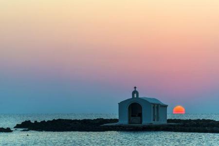
Location 40 km east of Chania, 20 km west of Rethymno Rivers Almyros and Perastikos, contributing to the natural lake and lush vegetation Beach 10…
The twelfth route of the E4 European Long DIstance Path in Crete is 20 kilometers long and lasts about 8 to 10 hours. You can follow it from May to September, it…

Location 58 km south of Chania Natural Environment Exit of the Samaria Gorge Access By hiking or sea transport Beaches Main beach split…

Location 75 km southeast of Chania History Unsubdued by conquerors from the Arab period through the Turkish occupation Activities Hiking on the E4…

The tenth route of the E4 European long distance Path is about 18 kilometers and lasts 6 hours and 30 minutes. The time it has to be followed is from May to October(due…
The ninth route of E4 European Long Distance Path is 13,5 kilometers and takes 7 hours and 30 minutes to follow it. The best season of the time to follow it is…

The seventh route of the E4 European Long Distance Path is 19,5 kilometers long and lasts 5 hours and 30 minutes, You can follow it during the whole year, it has…

The sixth route of the E4 European long distance path is about 13 kilometers and lasts 3 hours and 30 minutes. The best time to take it is the whole year and, especially…

The fifth route of the E4 European Long Distance Path in Crete is 20 kilometers long and lasts 8 to 9 hours. You should follow it from April to September and the…

Location South of Rethymno, 35 km away Amenities Hotels, cafés, tavernas, shops, post office, guesthouses Activities Water sports, boat trips to…

Location Rethymno, 25 km from Rethymno and 95 km from Heraklion Ecological Significance One of the most important wetlands in the southeastern Mediterranean…

The Platis or Amarianos River is supplied from the Amari valley and ends to the eastern side of the coastal settlement of Agia Galini. Platis was thought as the…

Argyroupoli is one of the most beautiful villages of the Rethimno prefecture, on the hill between the springs of the Petre and Mousela Rivers after which the names…

Agia Galini is a very picturesque coastal settlement, 60 kilometers from Rethimno and about 70 kilometers from Heraclion. It “hangs” over the beautiful small port…

Location 15 km from Heraklion on the national road to Chania Historical Significance Venetian fortress built in 1573 to protect the Gulf of Heraklion…

Location 3 km from the village of Fodele, 26 km from Heraklion Beach Sandy with crystal-clear turquoise waters and Blue Flag Amenities Western part…

Location Between Tsoutsouros and Kastri, Southern Crete Beach Features Coarse sand, rocks, clean South Cretan Sea waters Facilities Unorganized beach…

Location 22km northwest of Heraklion, near Agia Pelagia Beach Type Pebbly beach, crystal-clear waters, sheltered from winds Facilities Sunbeds, umbrellas,…

Location 8 km from Heraklion, a coastal village in the Malevizi municipality. Historical Significance Venetian fortress built on the acropolis of the…

Location 90 kilometers southeast of Heraklion Beach Dark gray sand, clean and calm waters, organized with sunbeds and umbrellas Activities Water sports, beach…

Location 70 km southeast of Heraklion Facilities Taverns, cafes, rental rooms Harbor Small harbor serving local fishermen Beaches Western small…

The Natural History Museum works under the framework of the University of Crete and is on the Sofoklis Venizelos coastal Street. The exhibition of the museum is…

Location 5 km southeast of Heraklion Timeline Inhabited from the 7th millennium to Roman times Architecture Multi-story palace covering 22,000 sq.m.…

Location 67 km from Heraklion and 2.5 km from Tympaki Beaches Two beaches: Katalyki (organized, sandy) and a western, unorganized beach (rocky and pebbly)…

The Treis Ekklisies (i.e. three churches) coastal settlement is behind the imposing Asterousia Mountains in the end of the Ampas gorge. It is an area that makes…

Agioi Deka is one of the most important villages in Mesara archaeologically and the ruins of the ancient city of Gortyna are there. The settlement is built on the…

The path in the Agios Charalampos gorge is a part of the E4 European long distance route. Following the route, you can go through the impressive Agios Antonios…

The Kerasia settlement is built on the eastern sides of the Chalepa hill, 340 meters above the sea level, on the 20th kilometer of the national Heraclion-Mesara…

Tilisos is built on the ruins of the ancient city of Tilisos and is in the eastern foot of Psiloreitis. The name of the settlement has been used for over 3.400…

The village of hippies, Matala, is approximately 70 kilometers in the south of Heraclion and is one of the most famous coastal settlements of the southern Crete.…

The male monastery of Vrontisi is in the southern foot of Psiloreitis, between the villages of Zaros and Vorizia, 550 meters above the sea level. Administratively…

The path to the green gorge of Agios Nikolaos with the amazing waterfalls starts from the Zaros Lake and ends to one of the forest of Greece, the Rouvas forest.…

The small temple of Agios Nikolaos from the 14th century is only preserved today from the important Zaros monastery. The church is 900 meters from the southern…

The old monastery of Panagia Kardiotissa is in a magnificent and verdant area. Some kilometers before the village of Agios Thomas (coming from Heraclion), in the…

Dionisi is a small, picturesque village of the Gortyna municipality and 57 kilometers from Heraclion. The settlement is built on the northern foot of Asterousia…

Asimi is in the Gortyna municipality and a modern town that serves the commercial, banking and other needs of the residents of the area. It is on the watershed…

The small settlement of Damania is about 35 kilometers from Heraclion, built in the Southeastern sides of Ofis hummock and 420 meters above the sea level in the…

Location Situated at the eastern edge of the Ziros Plateau, 31 km from Sitia Settlements Includes Agia Irini, Agrilia, Kalo Chorio, Lamnoni, Xerokampos,…

Location Northeastern Lasithi, 70 km from Agios Nikolaos Beaches Sitia's main beach, Blue Flag-awarded, 2.5 km long, with organized facilities and water…

A Minoan and a Roman mansion have been found in the south-eastern coastal Makris Gialos settlement of the Lasithi prefecture. The Minoan mansion was found in Plakakia.…

Location 12 km from Ierapetra, 45 km from Agios Nikolaos Beach Fine pebbles, crystal-clear waters, Blue Flag awarded Natural Beauty Surrounded by…

Location 70 km from Heraklion Altitude 900 meters History Inhabited since the Neolithic era, it remained uninhabited during the Venetian era due…

Kserokampos is one of the most beautiful beaches of the eastern Crete. Kserokampos is a settlement about 48 kilometers from Siteia and 28 kilometers from Palaikastro.…

Zakros is one of the most picturesque villages of Crete that combines the natural beauty with the alternative activities and the important archaeological sites.…

The amazing and magnificent Elounta is known for the powerful and famous people from all over the world that visit it. Its beaches, its clean, blue sea, and the…

The Archaeological Museum of Agios Nikolaos has been working since 1970 and is one of the most important museums in Crete. It is in the northern part of the lake,…


