


Alidakis Tower
Location Emprosnero, Municipality of Apokoronas, 40 km from Chania History Built by Venetians, reconstructed by Turks, destroyed by Sfakians in 1774 Architecture Four…
40 results found
Location Emprosnero, Municipality of Apokoronas, 40 km from Chania History Built by Venetians, reconstructed by Turks, destroyed by Sfakians in 1774 Architecture Four…

Location Tavris Plateau near Askifou Altitude1,200 m Access 7.5 km dirt road or a 2-hour hike from Ammoudari Facilities 45 people capacity,…

Location Southeast of the Omalos Plateau, at an altitude of 1,680 meters View Panoramic views of the Cretan and Libyan Seas, the Samaria Gorge, and Gavdos…

Location Aradena Gorge is located in Sfakia, Crete, and extends from the abandoned village of Aradena to the sea Length The gorge stretches over approximately…

Location 8 km west of Chora Sfakion Beach Features Pebbles, deep clear waters, tamarisk trees for shade Freshwater Springs Drinkable water springs…

Location South of Sfakia, 75 km from Chania. Historical Interest Venetian castle and the legend of the Drosoulites. Beaches Main beach, Orthi Ammos,…

Location 20 km from Chania, northeastern Akrotiri Peninsula Access From Chordaki, 10-15 minute hiking trail Facillities No organized facilities Name derived from…

Location 16 km from Chania, nestled at the foot of the White Mountains Main Attractions Theriso Gorge, Cretan Revolution Museum, Venizelos’ headquarters…

Location 70 km southwest of Chania, built on a peninsula between two bays Sights the Venetian fortress of Selino, the Museum of the Akrites of Europe…

Location 71 km south of Chania Access By foot or boat from Sfakia, Agia Roumeli, Sougia, Paleochora, Gavdos. History Connected to the ancient city…

Location 58 km south of Chania Natural Environment Exit of the Samaria Gorge Access By hiking or sea transport Beaches Main beach split…

Location 42 km south of Chania city Length 18 kilometers, with a hiking duration of 4-8 hours National Park Declared in 1962, part of the UNESCO…
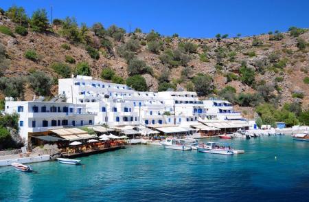
Location 2 km east of Chora Sfakion Natural Landscape Rocky terrain, steep cliffs, rich flora with holm oaks, pines, cypresses, and stone pines Hiking The…

Location 75 km southeast of Chania History Unsubdued by conquerors from the Arab period through the Turkish occupation Activities Hiking on the E4…

Location South of Rethymno, 35 km away Amenities Hotels, cafés, tavernas, shops, post office, guesthouses Activities Water sports, boat trips to…

Location 8 km south of Rethymno Trail About 1.5 hours of easy hiking through lush greenery Natural features Rich vegetation with plane trees, fig…

Mpali in the Rethimno prefecture is one of the most beautiful tourist places of the northern beaches of Crete. The coastal settlement is 32 kilometers from Rethimno…

Nida is the highest plateau in Crete as it is about 1.450 meters above the sea level and surrounded by the imposing mountains of Psiloreitis. It is a very beautiful…

Location 16 km from Lentas Gorge Length Approximately 8 km, starting narrow and widening near the sea Access Dirt road connecting Trypiti with Loutra,…

Location 18 km west of Heraklion, at an altitude of 440 meters History Founded by Venetians, it retains many architectural features from that period Residents 50…

Location Starts from Ano Archanes and ends near Knossos, Crete Length Approximately 6 km Main Points Sylamiano Gorge (accessible by car), Kato Mylos,…

Location 15 km from Heraklion Altitude 360 m. Activities Hiking on the E4 trail, visit to the Museum of Cretan History Sights Archaeological site in Fourni, amazing…

Location near Kato Archanes Activities Hiking, mountain biking Archaeological Significance Largest prehistoric cemetery in the Aegean (2400 B.C.…

Location 53 km from Heraklion, on the southern slopes of Mount Psiloritis Attractions The Monastery of Varsamonero, dating back to the 18th century, is…

Location 80 km from Heraklion, secluded beach with towering cliffs and emerald waters Attractions Chapel of St. Anthony, with a well of drinking water,…

Location Located approximately 60 km south of Heraklion Population The settlement is divided into Tsoutsouros and Pera Tsoutsouros, with the population significantly…

Location 20 km west of Heraklion, 2 km from Agia Pelagia Beach Turquoise waters, coarse sand, sheltered from winds Facilities Sunbeds, umbrellas,…

Location 20 km west of Heraklion Nature and landscape Lush vegetation, beaches with crystal-clear waters Beaches Main beach, Filakes, Kladissos,…

Location 64 km from Heraklion Attractions Picturesque chapels such as Saint Theodore, Saint Fanourios, Saint Nicholas, and Portela Gorge Population Approximately…

Location 70 km southeast of Heraklion Beach 7 km long, with coarse pebbles and golden sand Gorges Portela Gorge History Ruins of the ancient city of Keraia…

Just a few kilometers north of Heraklion, only 8 km from the city center, lies the picturesque area of Agia Irini, a green haven of peace, perfect for a quick escape…

“In Kapetaniana, whoever believes in God, he talks to Him”, Thanos Mikroutsikos. A heaven on Earth is in the holly hill of Kofina and stares the Libyan sea. Kapetaniana…
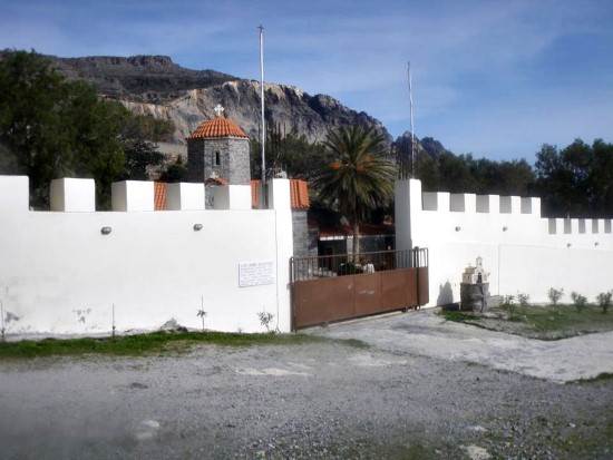
A magnificent path starts from the picturesque, mountainous village of Paranimfi and ends in the monastery of Koudoumas. The hiking takes many hours but the exploration…

The monastery of Koudoumas is very well protected by the imposing Asterousia Mountains, in the south of the cape of Martelos, and by the Libyan sea in the south.…

In the Achentrias settlement, in the Archanes-Asterousia municipality of the prefecture of Heraclion, there are many hiking options. You can either wander in the…

Location 18 km east of Ierapetra Hiking Route Approximately 20-minute hike on a moderate trail, accessible from the village of Agios Ioannis (elevation…


